


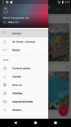
Mobile Topographer GIS


Mobile Topographer GIS leírása
A szeretett választás a szakemberek,
Mobil helyleíró ... megfelel ...
GIS .
Most már végre egy teljes felmérést korlátozás nélkül figyelembe bonyolultsága vagy adatmennyiség.
Próbálja ki most Mobile helyleíró GIS segítségével a három napos ingyenes próbaidőszak. Csak töltse le az alkalmazást, és folytassa azt jegyzési eljárás. Bár, meg kell adnia a számlázási adatokat, akkor nem kell fizetnie vége előtt három nappal az ingyenes próbaidőszak. Törölheti az előfizetést bármikor a három napos próbaidőszak, ingyenes. A díjak csak akkor fordul elő, ha a végén a három nap van még aktív előfizetéssel.
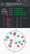
- Gyűjtsük GNSS leolvasott használatával nagyobb pontosságot (GPS, GLONASS, Galileo, Beidou, QZSS konstellációk támogatott).
- Kösd be a külső GNSS vevő keresztül Helyutánzatok és használata Mobile Topogrpaher GIS egy feldolgozó egység.
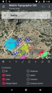
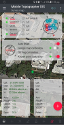
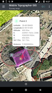
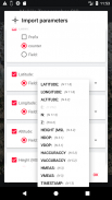
- Kijelző adatok WGS84 vagy helyi vetített CRS.
- konvertálása WGS84 helyi vetített CRS és fordítva.
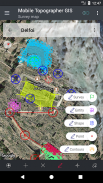
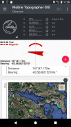
- Valós idejű projekció a térképen.
- *** ÚJ *** Egyéni kép vagy WMS szerver térkép háttérben.
- Keressen egy jelölt pontot a valós világban segítségével „Vezess engem”
- Számolja Orthometric magassága menet közben EGM modell vagy helyi magassági rács, ahol elérhető.
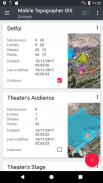
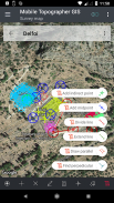
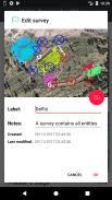
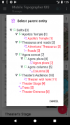
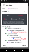
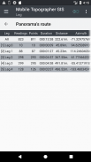
- szervezze meg a munkát a pontok - Shapes - szervezetek és felmérések. Most már létre az egyes pontokat, többpontos csoportok többrészes vonalláncok, és többrészes poligonok lyukak.
- Készítsen egy teljes rajz annyi adat, amennyit csak akar.
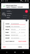
- *** ÚJ *** geodéziai eszközöket. Add közvetett pontok révén a következő lehetőségek közül: 1 pont + távolság + irányszög, 2 pont + Távolságok + Select, 2 pont + azimuths, 3 pont + távolságok, Midpoint vonal, Osztás vonal, kiterjesztése vonal, párhuzamos vonal merőleges vonal .
- Nest a munkahelyek, minden szinten fészkelő, hogy hozzon létre egy szuper-felmérés.
- Adatok megosztása munkahelyek aktív linkek.
- Az Exchange munkahelyek között a mobil készülék és az asztali számítógép, import - export funkciókat az összes elterjedt formátumot .txt, .csv, .kml, .gpx, .dfx és az alak fájlokat (.shp - .shx - .dbf)
- Együttműködés a partnerek cseréje és megosztása az egyik ponttól a teljes munkát.
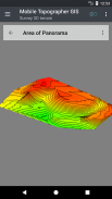
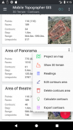
- Hozzon létre a 3D terep egy terület egyszerűen séta is.
- Számolja kontúrok és add hozzá őket a felmérés villám sebességgel.
- Az igazi 3D-s modellt közvetlenül a készüléken.
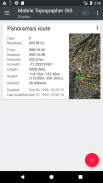
- Tárolja egy útvonalat az adatokat.
- Show GNSS műholdak jelet info mindkét iránytű nézet vagy AR.
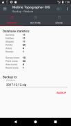
- Biztonsági mentés és visszaállítás az adatok segítségével SQL .db fájlt.
Üdvözöljük a korszak a mobil felmérés ...!
További információ a mobil helyleíró GIS:
http://applicality.com/projects/mobile-topographer-gis/
Töltse le a használati útmutatót kezdete:
http://applicality.com/app_documentation/web/MobileTopographerGIS_Manual.pdf
Mobile Topographer GIS - 6.0.15 verzió
(23-06-2023)

Mobile Topographer GIS - APK információ
APK verzió: 6.0.15Csomag: com.applicality.mobiletopographergisMobile Topographer GIS legújabb verziója
Egyéb változatok


Appok ebben a kategóriában

Ami még tetszhet...


